Polygon - TX: Difference between revisions
From imde.io
No edit summary |
|||
| Line 2: | Line 2: | ||
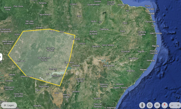
[[File:Polygon drawn using GoogleEarth.png|frameless| | [[File:Polygon drawn using GoogleEarth.png|frameless|600px]] | ||
GeoPolygons are defined by a set of by '''latitude''' and '''longitude''' coordinates, in the order the shape should be drawn, where the last coordinate is the same as the first. Below an example: | GeoPolygons are defined by a set of by '''latitude''' and '''longitude''' coordinates, in the order the shape should be drawn, where the last coordinate is the same as the first. Below an example: | ||
| Line 8: | Line 8: | ||
[0.731300,46.605612 -0.191250,46.704963 -0.191250,46.846894 0.177770,46.988824 0.447438,46.960438 0.589369,46.804315 0.688721,46.832701 0.731300,46.605612 0.731300,46.605612] | [0.731300,46.605612 -0.191250,46.704963 -0.191250,46.846894 0.177770,46.988824 0.447438,46.960438 0.589369,46.804315 0.688721,46.832701 0.731300,46.605612 0.731300,46.605612] | ||
==Related sites== | ==Related sites== | ||
*[https://www.ogc.org/standard/kml/ Open Geospatial Consortium (OGC)] | *[https://www.ogc.org/standard/kml/ Open Geospatial Consortium (OGC)] | ||
Revision as of 07:10, 12 April 2024
A Geopolygon is a shape on a map that links a number of individual grid references. A GeoPolygon is useful for grouping information or data about a particular area.
GeoPolygons are defined by a set of by latitude and longitude coordinates, in the order the shape should be drawn, where the last coordinate is the same as the first. Below an example:
[0.731300,46.605612 -0.191250,46.704963 -0.191250,46.846894 0.177770,46.988824 0.447438,46.960438 0.589369,46.804315 0.688721,46.832701 0.731300,46.605612 0.731300,46.605612]
